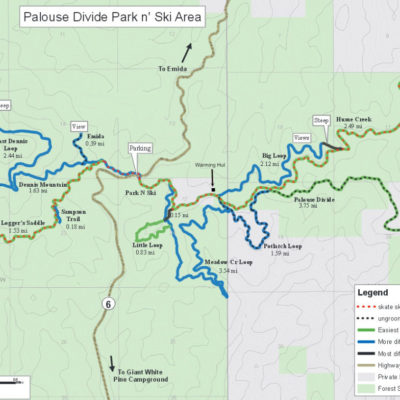
NORDIC Trail System
Through the hard work and sustained efforts of many local volunteers and the US Forest Service, motorized vehicles are officially prohibited on the Palouse Divide Trail System. This makes it favorable as a Nordic ski area. When possible, trails are groomed for classic Nordic skiing as well as skate skiing. One snowshoe specific trail is available but snowshoers may also used the groomed trails as long as they stay off the groomed tracks.
The Palouse Divide Ski Area boasts six groomed trails on the east side of Highway 6, and another two groomed trails on the west side of Highway 6. In all, there are over 20 miles of groomed trails, many of which are on gently sloping terrain. Outside the groomed area, there are many more miles of ungroomed routes.
The club offers a fun “challenge” – allowing you to get recognition for completing all the trails our club offers. And if you can do them all in a single day you’ll be recognized as an “elite challenge” completionist! Learn more on the “Challenge” page.
East Side Of HIGHWAY
Trailhead elevation is 3600’. All trail distances are calculated from the trailhead.
Palouse Divide Road
Easy
Distance: 1.7 miles each way to the Hume Road junction
Estimated time: 1-2 hours
Highest elevation is 3650’
The Palouse Divide Road (377) crosses the highway at the trailhead and proceeds along groomed forest service road for 1.7 miles to the junction of Hume Road. Left at the junction is Hume Rd. Right at the junction is the ungroomed Potlatch Loop. Palouse Divide Road continues straight ahead at this junction to Lane’s Overlook (another 1.6 miles) and Bald Mountain Lookout (approximately 7 more miles). Grooming usually stops at Lane’s Overlook. Our warming hut is alongside this section approximately 1 mile from the trailhead. There are a few hills and some areas can be icy.
Big Loop
Moderate
Distance: 5.5 miles roundtrip
Estimated time: 2–3 hours
Highest elevation is 3650’
The Big Loop trail starts at the east trailhead and proceeds along the Palouse Divide Road (377) for 1 mile to the junction of lower Big Loop. At the junction, take the left branch onto a narrow groomed trail to proceed on Big Loop in a clockwise direction (recommended direction). Approximately 1.7 miles from the junction, the trail begins a steep climb until it meets Hume Road after about 400 yards. This climb can be difficult depending on snow conditions and many skiers remove their skis for the climb, others sidestep or herringbone up the hill. At the top of the hill turn right onto Hume Road, continue on Hume Road to the Palouse Divide Road. At this intersection, turn right to follow Palouse Divide Road back to the trailhead. There are occasional views along both Hume Rd and Lower Big loop. The terrain is heavily forested and the skiing is mostly level – with the exception of the steep portion at the road junction. Because much of Big Loop is north facing, the snow conditions are often better on Big Loop and Hume Road than on Divide Road. Hume Road is especially nice skiing and is usually groomed for both classic and skate skiing.
Meadow Creek Loop
Moderate to difficult
Distance: 5.8 miles roundtrip
Estimated time: 3 hours
Highest elevation is 3650’
The Meadow Creek Loop trail starts at the east trailhead and proceeds along the Palouse Divide Road (377) for 1 mile to the junction Meadow Creek Loop. At this junction, take a right onto the narrow groomed trail to complete Meadow Creek Loop in a clockwise direction. The Meadow Creek Loop trail proceeds downhill through the forest until it opens up in a clear cut for a short distance. At the bottom of a short steep hill, there is a sharp right turn and then the trail continues gradually downhill and uphill along the former skid road for about 1.5 miles to another junction where it makes another sharp right turn and continues climbing uphill. After about 1 mile of uphill, it meets the lower part of Little Loop trail. Here you can either climb steeply for 200 yards to meet the upper portion of Little Loop or ski to the left and follow Little Loop in a clockwise direction. Whichever choice you make, you’ll need to take a right turn onto FS Road 3941 when you reach it. Once on the road, continue uphill about 0.5-0.75 miles and meet Palouse Divide Road about 0.3 miles from the main trailhead. Turn left at this junction and you will soon be back at the trailhead.
Little Loop
Moderate
Distance: 2.3 miles roundtrip
Estimated time: 1-2 hours
Highest elevation is 3650’
The Little Loop trail starts at the east trailhead and proceeds along the Palouse Divide Road for 0.3 miles to the junction with FS Road 3941. Turn right downhill and away from the Palouse Divide Road. In another 0.25 miles, you will see where the return leg of the Little Loop trail comes in on the left. Continue right and down the groomed road for a short distance to find the narrowed groomed track of Little Loop on the left. You will circle Little Loop in a counterclockwise direction. Little Loop is a short 0.8-mile loop that will bring you to the junction with Meadow Creek Loop. At this junction, you can turn left and trudge steeply uphill for 200 yards to meet the road portion of Little Loop or take a right turn and ski Meadow Creek Loop or turn around and retrace Little Loop. The 200 yard uphill trudge is the only difficult portion of the Little Loop trail and some people take off their skis and walk up the hill here. At the top of this hill, turn right on FS Road 3941 and head uphill back to the junction with Palouse Divide Road. At the junction, turn left and head back to the trailhead.
Hume Road
Easy to moderate
Distance: 8.6 miles roundtrip if you go all the way to the groomers’ turnaround on Hume Road
Estimated time: 3 hours
Highest elevation is 3650’
The Hume Road trail starts at the east trailhead and proceeds along the Palouse Divide Road for 1.7 miles to the junction of Hume Road. At the junction, turn left onto Hume Road (1479), a wide groomed road. There are occasional views along Hume Road. The terrain is heavily forested and the skiing is mostly level, usually very good for skate skiing. The groomers’ turnaround is the wide spot in the road about 2.5 miles from the junction where you will see the backside of a big metal sign that says “no vehicles past this point after Dec 15″. The snow conditions are often better on Hume Road than on Divide Road because it is north facing and generally protected from the wind.
Lane’s Overlook
Moderate
Distance: 6.6 miles roundtrip from the trailhead
Estimated time: 2-3 hours
Highest elevation is 3900′ at Lane’s Overlook
Follow Palouse Divide Road east of the highway to the junction with Hume Road. At the junction, continue straight and uphill for another 1.6 miles to a saddle. Lane’s Overlook is about 50 yards east of the main road at the saddle with exceptional views to the east over Emida. Grooming usually stops at Lane’s Overlook. If conditions permit, there is a picnic shelter here. The ride down is often spectacular.
West Side of Highway
East Dennis Loop
Difficult
Distance: 5.7 miles roundtrip
Estimated time: 3–4 hours
Highest elevation is 4400’
This loop trail starts on the northwest side of the highway and traverses on FS Road 377 for 1.6 miles before branching onto a side road and circling around East Dennis Mountain. The first 0.4 miles are relatively flat terrain but then the trail climbs 600 feet in the next 1.2 miles to a trail junction. At the junction, the recommended direction for skiing is to circle East Dennis in a counterclockwise direction by taking a right turn at the junction. The trail circles around East Dennis with moderate elevation change until it is about 1.5 miles past the junction. At this spot (marked by a blue sign), the ski trail deviates uphill for about 400 yards to a saddle. This portion of the trail is very difficult for skiing and some skiers remove their skis to hike up to the saddle. At the saddle, the ski trail meets FS Road 377 and returns back downhill and eventually to the trailhead. Views from the saddle and many places along the East Dennis Loop are excellent – both eastward to Emida and westward to Potlatch.
Samson Road to Loggers Saddle
Moderate
Distance: 6.0 miles roundtrip
Estimated time: 2-3 hours roundtrip
Highest elevation is 3800’ at the turnaround
The Samson trail starts at the west trailhead and proceeds along the FS Road 377 for 0.4 miles to the junction of Samson Road. At the junction, take the left branch and proceed on the groomed road. After approximately 0.5 miles, take the right branch heading slightly uphill and continue towards Loggers Saddle. Samson Rd is moderate in difficulty and only 2 short steep sections. There are occasional viewpoints along the route and an excellent viewpoint near the turnaround. There are several spur trails along the way and at the turnaround for the adventurous skier looking to break their own trails.
And More…
There are numerous other trail options at the Palouse Divide and parts of the listed trails can be combined for other trips. The trails listed here are the groomed trails and are meant as suggestions for skiers new to the area. Please consult the map of the Palouse Divide Ski Area for more information. If you choose to ski on ungroomed and unmarked trails adjacent to the Palouse Divide area, make sure you know the area and pack extra gear for warmth in case your return takes longer than expected.
If you’re looking for more challenges consider:
- Doing the club’s “trail challenge“
- Going on an organized overnight ski event
- Doing the club’s annual loppet
- Finding fellow members to ski with in the discussion group
- Exploring the many other regional trail systems